Posts

Showing posts with the label battle

Aberlemno Stone

Image
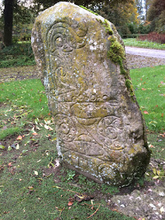
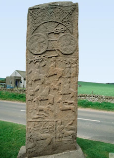
 Battle of Dunnichen This piece is a follow-up to  King Bidei The Picts have left a unique record of the battle in the form of a magnificent piece of sculpture.  The so-called Battle Stone in Aberlemno kirkyard - about four miles north of Dunnichen-is a Pictish stone, 2.3 metres high. It has a cross in heavy relief on one side and Pictish symbols on the other, above a vivid portrayal of warriors in battle. There are several good reasons for thinking that the scenes on the Aberlemno Stone depict the Battle of Dunnichen. Experts date it to the early 8th century, within a few decades of the event. It is not far from the site of the battle. And one set of warriors on the stone is wearing helmets with long nose-guards of a type known to have existed among the Anglo-Saxons. It is a remarkable record of the battle, showing superb details of weapons and methods of fighting – the Pictish equivalent of the Bayeux Tapestry. The Aberlemno Battle Stone has four separate images from the battle. At t

King Bridei

Image
 Our forgotten Pictish King The Battle of Dunnichen If the Pictish army led by King Bridei had lost to the invading Angles at the Battle of Dunnichen, then Scotland as we know it today simply would not exist. It was one of the most important battles of our early medieval history, and this is reflected in the fact that we know more about it than any other single event in 7th century Scotland. The Picts destroyed King Egfrith's Anglian army from Northumbria on May 20, 685, and their resounding victory helped form the political landscape of northern Britain for 200 years. They recovered territory, including Fife, which the Angles had occupied for almost 30 years. There had been a Pictish rebellion. against Northumbrian control in 672, which had ended in bloody defeat. Northumbrian sources luridly, though probably with exaggeration, tell us that the victors were able to cross dry-shod over two rivers, so full were they of the bodies of slain Picts. These rivers were the Carron and the

Turning the Tide

Image
 Turning the Tide The north-west frontier of the Roman Empire for 50 years from the 160s AD was Hadrian's Wall. To the north, forts stretched as far as Newstead on the Tweed, which extended Roman surveillance, while treaties with the Caledonians brought their influence to the edge of the Highlands and even into that great wilderness. The tribes had submitted reluctantly to Roman domination, and the peace of the northern frontier was broken on several occasions. In 208, the situation was so serious the presence of Emperor Septimius Severus himself was required as the Caledonians and the Macatae (whose name appears to survive in Dum Myot and Myot Hill near Stirling) fought a guerrilla campaign. Although eventually the Caledonians were forced to sue for peace it was not long before they were rebelling again. Severus, now terminally ill, sent his elder son, Caracalla, to bring the northern tribes to heel, but with the announcement of his the death in York, on February 4, 211, Gialla br

The Lost Battle

Image
The Lost Battle   Many theories exist over the venue for the Battle of Mons Graupius, but none is conclusive. More than a dozen places are rumoured to be the correct site—the more imaginative include the Gleneagles golf courses and the vicinity of Culloden. The name of the battle implies an isolated or at least distinctive hill, in other words, not the whole range of the Mounth. In the first printed edition of Tacitus's work, in 1480, a printer's error caused Graupius to appear as Grampius, which means the region Grampian took its name from a 15th-century spelling mistake.  Grampian Mountains link The very detailed description by Tacitus of the battle gives some clues regarding the lie of the land. The hill itself must have had a concave and rather steep slope. There was an open place for the Roman camp and a plain beside it, with wooded hills nearby and a Caledonian settlement within view.  Serious contenders for the site include: ● Duncrub near Dunning in Perthshire—may conta