Posts

Showing posts with the label alba

Kenneth MacAlpin

Image
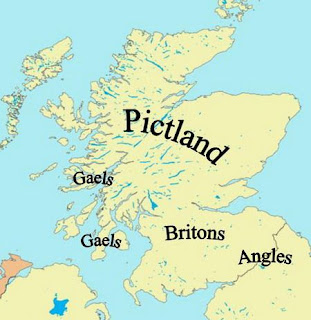
 King of Scotland Kenneth MacAlpin came out of relative obscurity to found a royal line that ended with Bonnie Prince Charlie almost a thousand years later. Famed for uniting the Picts and the Gaels, many legends have grown up about him. These produced a contradictory series of tales – few of which can be taken at face value. Kenneth – or in Gaelic, Cináed mac Ailpín was born about 800AD, in Dál Riata - which, despite the prestige of lona, had become a backwater. Most of the kings who ruled in this period paid tribute to the Picts, who were the regional superpower. The first Viking raids upon Britain and Ireland were taking place at this time. Lindisfarne was burned in 793 and Iona was attacked half a dozen times before 826. The Pictish heartland escaped serious attack from these early raiders, but the smaller and less well organised kingdom of the Gaels of Dál Riata where Kenneth was growing up – was thrown into disarray. The one spirited king, Aed the White, had died in 778 and none

Welsh Britonic

Image
 Central and Southern Scotland Place names rooted in Welsh Many place names in central and southern Scotland are derived from British, the language very close to Welsh which was spoken by the Northern Britons, Glasgow, originally Glasgau, means the green hollow in Britonic.  Edinburgh first appears in Welsh sources as the fort of Din Eidyn. When the Bernicians took over they translated this into English as Edinburgh. Lanark Lanerc: the clearing (Welsh-lanerch).  Peebles-Pebyl: the shielings (Welsh-pebyll).  Partick-Perthec: the copse (Welsh-perth); also the derivation of Perth, Paisley-Pasaleg a church word based on Basaleg, a Welsh borrowing from Latin-basilica, mother-church. Penicuik-Pen y gog: cuckoo's headland.  Cramond Caer Amond: the fort on the River Almond.  Moscow-Maes coll: Hazelfield (Welsh-maes and coll).  Bathgate-Baeddgoed: Boar-wood (Welsh-baedd and coedi)  Melrose Moelrose: the bald/bare headland.  Ecclefechan: perhaps the little church (Welsh-eglwys bechan) Many r

Govan Stones

Image
 Govan's ancient treasures It is easy to pass Govan Old Parish Church without suspecting the remarkable history that lies within. On the banks of the River Clyde, flanked by the Pearce Institute and the offices of a housing association, the church does not outwardly reflect antiquity. It was built in 1820, but the land on which it stands has been used for Christian worship since the 9th century when it was the Britons major Christian centre before that. It is home to a collection of early carved stones that attract archaeologists from all over the world.  Long before the birth of Christ, this was a significant place. Evidence has been found that Bronze Age people settled in Govan. It was then almost an island in the River Clyde, which could be reached only by a ford. It is not certain when the first church was built there, but the collection of sculpted stones spanning the 9th to 11th centuries suggests it was very early indeed. In fact, they represent a major school of stone-carvi

Ystrat Clud

Image
 Ystrat Clud Britons are the ancestors no one seems to have heard about. They were Christians, spoke Welsh, worshipped at Govan, and ruled from Carlisle to Glasgow for 600 years. They are the nearest thing we have to a 'native' people! They called it Ystrat Clud - Strathclyde. Their church was at Govan, their hunting estate at Partick, their stronghold was Cadzow near Hamilton. They were the Welsh forefathers of today's Glaswegians. They were the Britons. Of all the peoples who made up Scotland in the early historic period, the group who are probably least well. Known to the average Scot was the Britons. This is odd, as these are the people who were here when written history began, the nearest thing Scotland has to a “native” people. When the Romans arrived in Britain, first in the 1st century BC, and then during their forays into Scotland in the 1st century AD, Britain was inhabited by Britons from south to north. The Romans called them Brittones. The languages spoken thro

Forgotten Folk

Image
 Forgotten folk Close to the centre of Glasgow is a collection of early Scottish works of art, which attracts experts from around the world. It is a national treasure, as important as lona, yet its historical importance has been neglected by the city fathers and the tourist industry. So much so, that 16 priceless stone carvings were scooped up and dumped as rubble. It seems incredible, but these symbols of our Christian heritage from more than a thousand years ago are virtually hidden, looked after by the minister and elders of Govan Parish Church. Few people knew about them. And the reason appears to be simply that no one knows about the people who created them, the Britonic people, who were the first Glaswegians. The belief is widely held that The when the Romans left Scotland, they turned off the lights, plunging us into centuries of barbarism known as the Dark Ages. Wrong. This was the time when the Kingdom of the Scots started to take shape with the blending of differing nations a

Turning the Tide

Image
 Turning the Tide The north-west frontier of the Roman Empire for 50 years from the 160s AD was Hadrian's Wall. To the north, forts stretched as far as Newstead on the Tweed, which extended Roman surveillance, while treaties with the Caledonians brought their influence to the edge of the Highlands and even into that great wilderness. The tribes had submitted reluctantly to Roman domination, and the peace of the northern frontier was broken on several occasions. In 208, the situation was so serious the presence of Emperor Septimius Severus himself was required as the Caledonians and the Macatae (whose name appears to survive in Dum Myot and Myot Hill near Stirling) fought a guerrilla campaign. Although eventually the Caledonians were forced to sue for peace it was not long before they were rebelling again. Severus, now terminally ill, sent his elder son, Caracalla, to bring the northern tribes to heel, but with the announcement of his the death in York, on February 4, 211, Gialla br

Calgacus: Recorded

Image
 Calgacus: Recorded Tacitus dramatises the battle of Mons Graupius with the address to his army by the Caledonian general Calgacus.  His name means The Swordsman, and he is the first native of Scotland whose name has been recorded. "We are the last people on earth and the last to be free. Our very remoteness in a land known only by rumour has protected us up till this day. "Today the furthest bounds of Britain lie open and everything unknown is given an inflated worth. But now there are no people beyond us, nothing but tides and rocks and, more deadly than these, the Romans. "It is no use trying to escape by submission or good behaviour. They have pillaged the world: when the land has nothing left for men who ravage everything, they scour the sea. If an enemy is rich, they are greedy, if he is poor, they crave glory. "Neither East nor West can sate their appetite. They are the only people on earth to covet wealth and poverty with equal craving. They plunder, they bu

The Lost Battle

Image
The Lost Battle   Many theories exist over the venue for the Battle of Mons Graupius, but none is conclusive. More than a dozen places are rumoured to be the correct site—the more imaginative include the Gleneagles golf courses and the vicinity of Culloden. The name of the battle implies an isolated or at least distinctive hill, in other words, not the whole range of the Mounth. In the first printed edition of Tacitus's work, in 1480, a printer's error caused Graupius to appear as Grampius, which means the region Grampian took its name from a 15th-century spelling mistake.  Grampian Mountains link The very detailed description by Tacitus of the battle gives some clues regarding the lie of the land. The hill itself must have had a concave and rather steep slope. There was an open place for the Roman camp and a plain beside it, with wooded hills nearby and a Caledonian settlement within view.  Serious contenders for the site include: ● Duncrub near Dunning in Perthshire—may conta

The Blue Men

Image
  The Blue Men The three Shiant Islands, where the amazing find of the priceless gold tore was made, lie in the waters of the Minch, east of Harris, and are known in Gaelic as the enchanted isles. Strong tidal currents are not the only hazard facing those who venture into these waters. Legend has it that the Blue Men of the Minch live in the Sound of Shiant, and that they are either fallen angels who landed in the sea after being ejected from Heaven, or storm kelpies, Sailors are advised to treat the Blue Men with great respect. They should speak to the Blue Ones in rhyming Gaelic couplets, or else be dragged to the bottom of the Minch. A minister in the late 19th century recorded his meeting with one of them. He said "a blue-covered man, with a long, grey face, and floating from the waist out of the water came, so close, I could almost touch him.'' The strikingly attractive Shiants are a cluster of three islands and several islets made of basalt, formed by the eruption of

Broch Towers

Image
Towering Enigmas     For most of us, our home is a part refuge, part status symbol. That was just as true during the later Bronze and Iron Age, between 1,000 BC and 100 AD when Scotland was covered with the farms of settled and prosperous tribes. The centrepiece of these farms was a large roundhouse. In the south and east of the country, where timber was plentiful, these were usually massive wooden buildings with conical roofs rising up to 40ft above the ground. Unfortunately, centuries of intensive farming have wiped out all traces of them from the Lowlands. Further north, wood was less easily available, and so prehistoric farmers built their roundhouses from stone. These Atlantic roundhouses, so-called because they are most common around Scotland's Atlantic coasts, include the most imposing of all Iron Age buildings - the broch towers. Among the finest architectural achievements of prehistoric Europe, they are found only in Scotland. Some of the best examples are located in Orkne